Local News
This summer’s extreme heat is less a series of isolated events than one evolving atmospheric story.
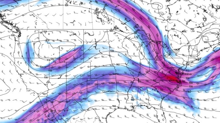
This map shows the jet stream dipping south of New England, bringing the return of cooler air in early May 2024. Pivotal Weather
One aspect of being human is that many of us tend to compartmentalize a lot of our lives. In reality, each “compartment” is more connected. I know I feel best when all the different aspects of who I am are actually entangled. It might look messy, but there’s a flow to it. Picture something like writing this article at a friend’s house, taking photos of plants for a future piece, then taking a break to make a healthy lunch, even going for a walk, all while looking at weather maps. I love it when these various parts of my life work together. And in a way, weather is one of the most inherently connected experiences, but it often gets compartmentalized in storytelling.
This week is hot here, there’s flooding over there, and it’s too dry somewhere else. Different boxes, different shelves, different news headlines. Pick up a paper in Paris this month and it’s France’s punishing summer, one of the worst on record. Pick up one in Salt Lake City and its historic drought, fire risk, and low reservoir levels. Locally, it’s our own 90-degree count.
Different headline, different place, same sky.
Zoom out to roughly 30,000 feet above Earth and, although you won’t see it, there’s a ribbon of air circulating the middle latitudes of the planet — moving and controlling our weather. It’s this band of wind, the jet stream, that’s responsible for everything from big snowstorms and Arctic cold to prolonged rainy spells and droughts — and, of course, the heat that’s been popping up all over this summer, from Boston to Barcelona.
The jet stream doesn’t flow in a straight line. It snakes north and south in slow, sprawling waves. Under the right conditions, those waves can get trapped in a kind of atmospheric channel, and instead of moving on and dispersing their energy the way they normally would, they resonate and amplify in place. Some atmospheric scientists call this “quasi-resonant amplification” and it’s one explanation for why a ridge of high pressure, or a trough, can get stuck over one region for days or even weeks instead of passing through in the usual few days. This stagnation can lead to the extremes we are becoming more accustomed to.
But even that explanation isn’t fully settled — researchers testing it in simplified models haven’t been able to reproduce the amplification it predicts, and caution against crediting it as the proven cause of any single heat wave. Which is, in its own way, the point: we want our explanations tidy. Rarely is the truth what it usually is — a tangle of small, related things, no single thread on its own. This jet stream did this. This heat dome caused that. The atmosphere isn’t cooperating with the tidy version. It’s still one muddled system, even where the science hasn’t caught up to name how the threads connect.
For years, the world’s climate authority, the Intergovernmental Panel on Climate Change (IPCC), has been criticized from opposite directions — accused of alarmism by some, of being too slow to sound the alarm by others. The truth is neither: the IPCC’s global temperature projections have tracked remarkably well since the 1990s.
But a global average is its own kind of box, so to speak. It smooths over the regional extremes, and that’s exactly where the caution crept in — models have struggled to capture what happens when the jet stream itself slows and a ridge locks in place for days, the way this heat dome just did over France this summer and is doing out west this week. We likely don’t fully understand how these smaller-scale extremes emerge from the larger chaos of the atmosphere, from the ground to the stratosphere. There’s something compelling about the scientists still out there chasing the threads, trying to make sense of it.
All of this isn’t a metaphor; it’s a mechanism. Parts of the high latitude river of air that traverse the globe, baked areas from the UK to Western Europe through two stretches of, in some cases, 100-plus-degree heat this summer, while farther downstream, days or weeks later, another kink — like the one now settling over Utah and Montana — arrives with extreme heat warnings of its own. It is not unrelated to the one that, until a few days ago, was bringing Boston’s much-needed wet and blessedly cooler weather. Different areas, different headlines, but the same jet stream.
That same current isn’t finished with us yet. Right now, heat advisories and extreme heat warnings stretch clear across the northern tier, from Montana to Maine — with the top of the map running hottest compared to average, of all places. It won’t last, however. By the weekend, it’ll be gone.
I find that part the most challenging to explain, because there isn’t a simple version. The same wave that sparked the intense heat over Provence and the Wasatch is the same one that now sits over the Northeast. It looks like three separate heat waves, wearing different names in different weather stories, but we’re just living under one interconnected wavy loop of air.
I keep testing what happens when I let the compartments of my life run together instead of staying separate — it’s a small experiment I run most days, and it usually pays off. The scientists chasing quasi-resonant amplification are running a bigger version of the same test: What happens when you stop treating a heat dome in Montana and a heat wave in Maine like two different problems? So far, the atmosphere keeps failing to give them a clean, separate answer — perhaps there isn’t one.
Sign up for the Today newsletter
Get everything you need to know to start your day, delivered right to your inbox every morning.